 |
|||||||||
 |
|||||||||
 |
|||||||||

SongheesA Lukwungen Landscape Thunderbird Park is located within the traditional territories of the Lukwungen (Songhees and Esquimalt) First Nations, who speak a version of the North Straits Salish language. This area was a significant meeting and resource-gathering place for the Songhees and Esquimalt peoples, as well as groups throughout the Northwest Coast who visited the area to trade and socialize. |
||
|---|---|---|
|
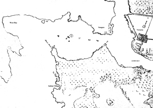
Part of an 1854 map showing the Old Songhees Reserve, Fort Victoria and James Bay. Thunderbird Park is located at the bottom right of the bay. The mottled trees on the far right are representative of the open Garry Oak parkland environment. HBC: G.1/131 (N8362) |
|
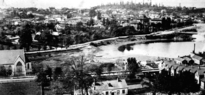 |
Thunderbird
Park is now located in the treed area across the water (James
Bay) at the centre of this 1880s photograph. The Songhees came
to this area in the spring to collect camas bulbs from the surrounding
Garry Oak parklands. Note the canoe pulled up on the beach at
the back of James Bay. BC Archives: A-03397 |
|
Tom
Sampson: Tsartlip welcome to Salish lands. Speech in Sencoten.
First Peoples Festival, Victoria Native Friendship Centre & Native
Participation Committee, Commonwealth Games, 1994. RBCM GNWC-V-036. |
||
Use the controller on the left
to play video clip |
||
Tom Sampson: Tsartlip
welcome to Salish lands. Speech in English. First Peoples Festival,
Victoria Native Friendship Centre & Native Participation Committee,
Commonwealth Games, 1994. RBCM GNWC-V-036. |
||
Use the controller on the left
to play video clip |
||
| Resources | Human Interaction with Thunderbird Park | Mat Making |
Weaving | Marine Resources | Birds | Old Songhees Resources | Esquimalt Reserve |
Potlatches | Canoes |
| Back to Map |